Saturday, 22 July 2006
cross-country trip day 4: cody, wy to rapid city, sd

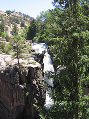 We left Cody at around 9 this morning, expecting that today’s drive would be somewhat tedious. We were totally unprepared for how astoundingly beautiful the Shell Basin in the Bighorn National Forest would be. The road winds through gorgeous rock formations, with lots of places to pull off and gaze wonderingly at the creek rushing through the gorge below, or the incredible layers of rock visible on the sheer cliff faces.
 I took a ton of photos, but Lane is currently using my Powerbook and I don’t (yet) have an easy way to get the pictures off my camera and onto this PC laptop.
Now we’re settled into the Holiday Inn Express Hotel & Suites in Rapid City, SD, where we’ll stay for two whole nights. (Point of information: it’s very hard to find a room in a decent hotel in Rapid City on a Saturday night in July. Happily, even though the Holiday Inn site and Expedia both claimed this hotel was fully booked, Priceline managed to find a us a room.) Tomorrow is tourist day…we’ll be visiting Mount Rushmore, Custer State Park, and Wind Cave National Park, returning to Rapid City via the Peter Norbeck Scenic Byway. On our way out of Rapid City on Tuesday, we’ll stop at Badlands National Park, on our way to the Corn Palace in Mitchell, SD.
TrackBack URL for this entry: http://mamamusings.net/mt/liztrack.cgi/1252
I plan to blog our trip as well, when we drive from Palo Alto to Tallahassee in late August. I had treated myself to a PC card multicard reader for my laptop, and already found it very useful while at ALA. (Among other things, I don't have to worry about filling up my camera.) Mulling over the mapping tools... sorry that Google maps is so lame. Thanks for the heads up! Gives me time to plan and experiment.
Karen, I *really* like Microsoft Streets & Trips, which allows us to calculate driving time based on things like whether we tend to go the speed limit, and how often we stop for breaks (and for how long). It makes it easy to add waypoints, and to schedule stops (for hours, like a park, or nights). It also prints nice TripTik-like maps. Highly recommended.
Oh, and the camera issue isn't the physical connection, it's the software. I'm an iPhoto addict. :)
Don't forget the free icewater at Wall Drug and gaze on the jackalope!!
BTW we had the Buffalo herd surround our car in Custer st park!
Yep, we do plan to stop at Wall Drug.
We saw bison at Custer, but it was 100 degrees outside and they were pretty sluggish. We did get some decent photos, though, which I'm currently uploading to Flickr. I'll blog the day later tonight.
Thanks for signing in, . Now you can comment. (sign out)
(If you haven't left a comment here before, you may need to be approved by the site owner before your comment will appear. Until then, it won't appear on the entry. Thanks for waiting.)
